1
enhance the vegetation reflected signal from measured spectral responses by
combining two (or more) different wavebands, often in the red (0.6-0.7 um) and NIR
wavelengths (0.7-1.1 um).
The MODIS vegetation index (VI) products provide consistent, spatial and
temporal comparisons of global vegetation conditions which can be used to monitor
the Earth's terrestrial photosynthetic vegetation activity in support of phenologic,
change detection, and biophysical interpretations. Gridded vegetation index maps
depicting spatial and temporal variations in vegetation activity are derived at 16-day
and monthly intervals for precise seasonal and interannual monitoring of the Earth�s
terrestrial vegetation.
Two vegetation index (VI) products are made globally robust and are produced
globally for land. One is the standard normalized difference vegetation index (NDVI),
which is referred to as the �continuity index� to the existing NOAA-AVHRR
derived NDVI. There is a 20-year NDVI global data set (1981 - 2000) from the
NOAA- AVHRR series, which could be extended by MODIS data to provide a long
term data record for use in operational monitoring studies. The second VI product is
the �enhanced� vegetation index (EVI) with improved sensitivity over high
biomass regions and improved vegetation monitoring capability through a decoupling of the canopy background signal and a reduction in atmosphere influe nces.
The two VIs complement each other in global vegetation studies and improve upon
the extraction of canopy biophysical parameters. A new compositing scheme that
reduces angular, sun-target-sensor variations, with an option to implement BRDF
models, is also utilized. The gridded vegetation index maps use MODIS surface
reflectances corrected for molecular scattering, ozone absorption, and aerosols, as
input to the VI equations. The gridded vegetation indices include quality assurance
(QA) flags with statistical data that indicate the quality of the VI product and input
data. The MODIS VI products are generated at multiple spatial resolutions every
sixteen days and each calendar month. Currently, the MODIS VIs are produced at
250m, 500m and 1km resolutions. A coarser, 0.25 degree, climate modeling grid
(CMG) version is forthcoming. For production purposes MODIS VIs are produced in
tile units that are approximately 1200km by 1200km in the integerized sinusoidal grid
projection. Only tiles containing land features are considered to help reduce
processing and disk space requirements. When mosaicked, all tiles cover the
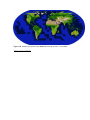
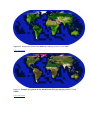
terrestrial Earth and the global MODIS-VI can thus be generated each 16 days and
each calendar month.In this user guide we introduce the MODIS VI science algorithm,
file formats and data structure. This document serves as a reference manual for end
users when acquiring, accessing, or analyzing MODS VI products.
File Format of the MODIS VI Products
The MODIS production and science team chose the Hierarchical Data Format-Earth
Observing System (HDF-EOS) format, which is the standard archive format for EOS
Data Information System (EOSDIS) products. Each MODIS-VI file contains two
separate structures: