1
Integrated Water Resources Management Documents
3 Qual2K Overview
3.1 Obtaining the model
The Qual2K model is developed for the
United
States
Environmental
Protection Agency (USEPA).
You can download a zip file containing
the latest version of the model and
supporting documentation for free from
http://www.epa.gov/Athens/wwqtsc/ht
ml/qual2k.html. (Note that the user
manual is in English).
Model development is ongoing and
updates are issued on the website.
3.2 The model theory
The Qual2K model is a onedimensional model and so it is
assumed to be well-mixed in the
vertical and lateral directions. It is a
steady state model, so the flow and
water quality cannot evolve over time.
Diurnal variations in water quality (due
to the diurnal variation in temperature
and sunlight) can be simulated.
3.3 How the model functions
Full details of the model’s functionality
are given in the user guide (Chapra et
al, 2006); an overview is given here.
Qual2K is written in an Excel
spreadsheet with VBA macros and a
FORTRAN program to undertake the
calculations.
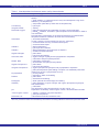
The user enters hydraulic, water
quality, and climatic data (see
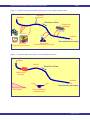
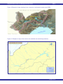
Section 3.4). Figure 2 shows examples
of typical inflows, discharges and
abstractions that can be included in the
model. For all inflows and discharges,
both a flow rate and water quality
values must be provided. For
AN1.5
abstractions,
necessary.
only
a
flow
rate
is
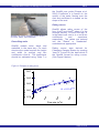
Figure 3 shows examples of typical
hydraulic parameters that may be
included in the model. This includes
dimensions of river cross-sections,
dimensions
and
parameters
to
describe weirs, dams or waterfalls, and
the bed slope along the river. Where
sufficient data is available, rating
curves can also be included into the
model.
Guidance is given in the Qual2K user
manual on how to describe hydraulic
structures in the model.
In a Qual2K model, the river is divided
into several reaches then each reach
is divided into a user specified number
of
elements.
Abstractions
and
discharges can be positioned at any
point along the river. If a weir, dam or
waterfall is to be included in the model,
this must be positioned at the end of
the reach, and that reach must consist
of only one element.
Data at inflows are needed for the
model’s calculations and can be
entered into the model “Headwater”,
“Diffuse Sources” and “Point Sources”
worksheets. (Physical dimensions and
descriptors of the reaches should also
be
entered
into
the
“Reach”
worksheet.)
Water quality and flow data for
calibration should be entered into the
yellow “Hydraulics Data”, “Temperature
Data” and “WQ Data” worksheets.
These values are not used in the
model calculations but are plotted on
the output graphs for comparison with
the model output during the calibration
process.
Page 3 of 19