1
Map Screen
from XM Satellites. Listed below are the items that can be displayed
and what they mean:
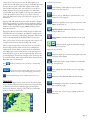
STARTUP- Anywhere Map is connecting to the Bluetooth Radio in
the ATC for the com port and connection of the WX Radio (WX
Worx Dual Ensemble receiver).
INIT= Initialize. Anywhere Map is searching in an attempt to
connect to a WX Radio.
ACT CHK= Activation Check. Anywhere Map is checking the
activation status of the WX Radio.
NOTE: NEVER REMOVE THE ATC MEMORY CARD while
Anywhere Map is running as database corruption may occur.
OVERVIEW:
The main map screen is highly interactive and can be easily
customized to show your choice of standard aeronautical chart items
as well as numerous (unique to Anywhere Map- features including
Cones of Safety, a Virtual Glideslope indicator, and Obstacles as low
as 200’ AGL. Many of the items you see on the main map screen are
able to be tapped for more information. A single tap on items such
as airports, obstacles, navaids, graphical METAR flags, and
MOAs/Restricted areas will bring up a small text box containing
‘quick’ information about the selected item. These text boxes will
auto-hide after a few moments, OR can be cleared immediately by
tapping the “Clear All Tags” button that appears just below the
airplane icon while any text boxes are activated. Double tapping
(tapping the same item twice in rapid succession) will bring up the
complete details for the selected items. Airport data screens deliver
items such as radio frequencies, remarks, raw textual METAR/TAF
information, runway data, and Taxi Express™ GPS enabled taxiway
diagrams. Adding the selected airport or navaid item to the flight
plan can also be done on these screens. For map screen
customization instructions please reference the VIEWS section of
this manual.
The map screen also contains features that are always displayed and
are always located in the same fixed position for easy reference
regardless of user configuration.
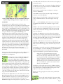
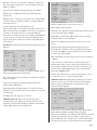
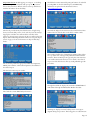
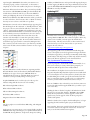
Starting in the top left, you’ll find the Flight Timer
area. This area can be used to display 3 different
timers. FT or Flight Timer can begin at your
designated taxi/runway speed and keeps track of the
time aloft. ET or Elapsed Timer is a ‘stopwatch’ type
function, which can be handy on approach. ZT or Zulu Time can
also be displayed making second-guessing your time conversion from
local to Zulu time a thing of the past. To use this area, simply tap on
it to change modes until the desired timer is selected. The ET can be
cleared by tapping on the elapsed time and then tapping the blue
“Clear ET” tag that comes up. Zulu time is calculated automatically
using the internal NMEA GPS clock.
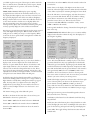
Directly below the Flight Timer area is the weather status area. The
WX status displays quite a bit of data about the XM WX portion of
Anywhere WX with a single line of text. This single line will toggle
between the current state of the WX Radio receiver/age of the
NEXRAD file displayed and the quality of the signal being received
REQST= Request. Anywhere Map is requesting the appropriate
items for the WX Radio unit to decode for display on the map
screen.
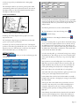
WX: --- = the first NEXRAD radar file has not been received yet.
Normally the first radar file takes 4-6 minutes to appear on the
screen
WX:0m = The current radar file being displayed on the screen has
just been delivered via the XM WX broadcast and is currently 0
minutes old. 3 minutes after this image is delivered the time will
then show “WX: 3m”
ACTXM = The WX Radio receiver has confirmed to Anywhere
Map that it is not activated or that it hasn’t been used recently and
doesn’t know how to decipher the current encryption of the weather
files being delivered by XM satellites. See page 19 of this manual for
more WX Radio Activation/Refresh instructions.
XM-ANT = XM Antenna is not connected or is reported to be
defective by the WX Radio box. Try removing/re-inserting the WX
Radio antenna. If this message persists, the antenna may need to be
replaced.
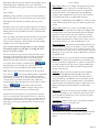
Signal quality is reported by 3 green bars for GOOD signal, 2 yellow
bars for FAIR signal, 1 red bar for POOR signal, and NOXMSAT
which means the antenna is connected but doesn’t have any
reception normally due to a poor/non-existent view of the sky.
NOTE: After boot of the Anywhere Map software and
connection to the WX Radio box has been established through
Bluetooth, the signal quality to XM satellites will be displayed
following INIT, ACT CHK, and REQST phases have completed
(approx 30 seconds or less). Once an acceptable level of signal
(GOOD or FAIR) has been maintained for 4-6 minutes, the first
WX files will begin to show up automatically on the map screen.
More on the XM Weather operations can be found in the XM
Weather section of this manual.
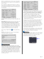
The last line on the top left map screen area is the Range indicator.
The example shown on the previous page illustrates a 37 statute mile
range. This distance is measured from the aircraft position on the
map screen to the top arc of the compass rose.
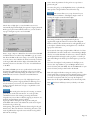
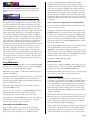
Moving on to the upper right corner of the screen you’ll find the
GPS status.
This area will display “NO SAT” if the internal GPS
hasn’t acquired at least 3 satellites sufficient to provide
Page 2