1
PHOTOMOD
2. If you combine raster map from different fragments (if for example big paper source
was scanned by overlapped portions) you need:
• Open one of the fragments (it is recommended to begin with the fragment
located inside common image)
• Make first step orientation (Raster list / Properties/Place by two points /
Horizontal alignment)
• Add second raster and georeference it to the first one: (Raster list /
Properties/ Place by two points with scaling and rotation) using two points on
each raster
• Cut raster by drawn outline (Raster / Properties / Extract / Manually)
For example. There are 3 raster images converted to RSW format from BMP, PCX or
TIFF format. To combine them to raster map you need:
1. Georeference first raster by two points on the raster and vector map or by control
points set.
2. Georeference second raster by two points on the second raster and corresponding
points on the first raster (or somehow else)
3. Georeference third raster
4. Set visible area for each of rasters
5. Save combined raster map to exchange format. As a result this map can be loaded
as a whole from RSW format.
6.
Appendix А. DIR file structure
DIR file used to combine different vector and raster maps to Work region. DIR file contains
name of region file, name of region, name of classifier and names of loading SXF, TXT and
MAP files.
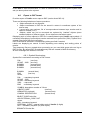
File DIR has a following structure:
DIR
NAME < region name >
< name of file-classifier RSC >
< name of data file >.........
< name of data file >
< Region name > - region name (up to 24 characters). It is optional field. If it does not
exist it will be equal to the name of sheet of first SXF file, included to the region.
< Name of classifier file> - name of RSC file, mandatory field
< Name of data file > name of binary or text SXF file or MAP file, mandatory field.
First file string must contain DIR keyword. The second string is a classifier file name. For
example MAP103P.RCS. Following strings contain names of SXF, TXT or MAP files in
arbitrary order. Each file name is stored in separate string. If file name does not include
paths, files must be stored in DIR file directory (or its subdirectories).
For example. DIR file is stored in C:\DATA directory. SXF file name looks like
\OMAHA\omaha.sxf. So full path to SXF file is C:\DATA\OMAHA\omaha.sxf. You can also
include full paths to file names.
Different files may be stored in different directories.
All files should contain maps of common type and projection.
If the Work region covers several zones of coordinate system SXF file that covers maximum
area should be at the first place in the SXF files list. All other SXF files will be georferenced
to the coordinate system of the first one.
7.
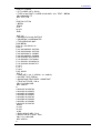
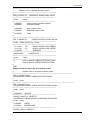
Appendix B. Sample of SXF file
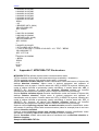
// EXAMPLE of a text SXF FILE
// RECTANGULAR COORDINATES
// TOPOGRAPHIC MAP
P000 BERN
© 2009
66