1
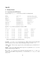
print($0);
}
If your data sets contains values between −2 and 3, say, and you would like to use the rainbow colored
colorscale col.13.cpt, use
awk-f$igmt_root/colminmax.awkmin=-2max=3\ldots\\$igmt_root/colormaps/col.13.cpt>
new_colormap.cpt.
Here, “. . . ” means that the above should be in one line.
Also, you might want to use the grd2cpt function of GMT that can be accessed over createcolormap
menu item.
B
Modifying iGMT
iGMT may be freely modified and distributed as long as modified versions are not called iGMT. There are
plenty of easy possible future enhancements one could think of, for instance interactive design of colormaps,
support of more complicated user data sets and multiple layers of raster data. When this extensions become
available, they will be included in future versions. Some common modification (as opposed to extension or
enhancement) tasks are described below:
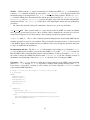
Using other path names for the data sets. All pathnames to data locations are assigned in igmt_configure.
tcl. All raster data sets have two variables assigned to them: raster data(i) and raster_colormap(i),
they refer to the location of the raster data set number i and the location of the default colormap, respectively. Simply add a line like setraster_data(3)"/home/user/gtopo30/topo_6.2.img" to your
igmt_siteconfig.tcl file, if your GTOPO30 dataset (number 3 internally) is in /home/user/gtopo30/.
The equivalent variables for polygon data are called poly_data(i), and it is simplest to search for the
appropriated variable names in igmt configure.tcl.
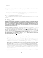
Including new data sets. You will have to do these things: (to be expanded)
1. Add the data location and its parameters to the igmt_configure.tcl file.
This should be easier now with version 1.2 since we have replaced most global variables for raster and
polygon data issues with arrays, such that you can simply add one more entry at the back. Right now,
raster data sets are reserved from 1 to 11, with the limit being set to (variable: nr_of_raster_data)
20 raster data sets in total. Polygon data sets are restricted to 25, and right now all sets up to 20 are
filled. Read through igmt configure.tcl to see how the default data sets are implemented here.
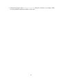
Parameters for raster data are: location of data file, default colormap, geographical limits (East, West,
South, and North boundaries), integer boundaries only (on/off), the maximum resolution (in arc minutes), and resampling at other than default grid spacing (on/off). For polygon data: location of data,
symbol size, symbol color, . . .
2. Add the data selection choice to the Datasets menus. This is done in igmt_menues.tcl and igmt_
datasets.tcl.
22