1
Sitecheck Review User Guide
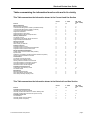
Title
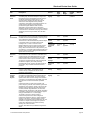
Description
Source
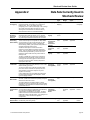
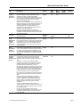
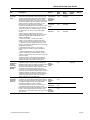
Potential for
Landslide
Ground
Stability
Hazards
This assessment is based on data produced by the British British
Geological Survey ("BGS") using the latest geological
Geological
mapping information and interpretation by BGS geologists. Survey
Maps of this natural subsidence hazard are derived from
1:50,000 geological maps.
Data
Type
Date
Range
Update
Cycle
Section
Polygon & Not
Text
Applicable
British
Geological
Survey
Other
Factors
Polygon & Not
Text
Applicable
British
Geological
Survey
Other
Factors
Polygon & Not
Text
Applicable
British
Geological
Survey
Other
Factors
Text
Not
Applicable
Historic
In small areas of the country where the 1:50,000 scale
data is not available, 1:250,000 mapping for bedrock
geology and 1:625,000 for Superficial geology has been
used.
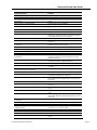
The Potential for Slope instability occurs due to particular
types of slope becoming unstable under certain
circumstances, causing down-slope movement of the
ground and disruption to buildings. A combination of
factors, including, amongst others, the rock type, the
presence of excess water (natural or relating to man-made
activity), the angle of the slope, and construction work, for
example, cuttings or embankments, can all contribute.
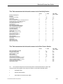
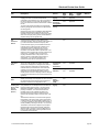
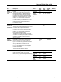
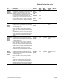
Potential for
Running Sand
Ground
Stability
Hazards
This assessment is based on data produced by the British British
Geological Survey ("BGS") using the latest geological
Geological
mapping information and interpretation by BGS geologists. Survey
Maps of this natural subsidence hazard are derived from
1:50,000 geological maps.
In small areas of the country where the 1:50,000 scale
data is not available, 1:250,000 mapping for bedrock
geology and 1:625,000 for Superficial geology has been
used.
Running sand occurs when loosely-packed sand flows
(runs) because water flowing through the spaces between
the grains reduces the contact between the grains and
they are swept along in the flowing water. This may
happen where springs occur at the base of sand outcrops,
where excavations in sand go below the water table,
around leaking drains or water pipes.
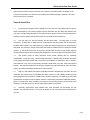
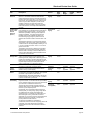
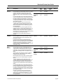
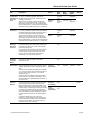
Potential for
Shrinking or
Swelling Clay
Ground
Stability
Hazards
This assessment is based on data produced by the British British
Geological Survey ("BGS") using the latest geological
Geological
mapping information and interpretation by BGS geologists. Survey
Maps of this natural subsidence hazard are derived from
1:50,000 geological maps.
In small areas of the country where the 1:50,000 scale
data is not available, 1:250,000 mapping for bedrock
geology and 1:625,000 for Superficial geology has been
used.
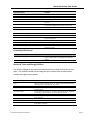
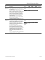
Shrinking/Swelling Clay can change volume due to
variation in ground moisture. This can cause ground
movement, particularly in the upper 2 metres of the
ground, which may affect foundations. Ground moisture
variations can be related to a number of factors, including
weather variations (annual or longer term), vegetation
effects (particularly growth or removal of trees) and manmade activity.
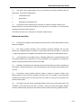
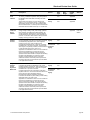
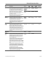
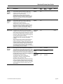
Potentially
Contaminative
Features from
Historical
Building Plans
This dataset contains potentially contaminative features
such as asbestos, petrol, oil and tanks captured from
Historic Building Plans.
Landmark
From 1885
to 1970
The Historic Building Plans were produced by the Londonbased firm Charles E. Goad Ltd. as fire insurance plans,
dating back to 1885. The firm ceased production of fire
insurance plans in 1970. Most of the important towns and
cities of the British Isles are covered. Historic Building
Plans are usually at the scales of 1:480 (1 inch to 40 feet)
for the British Isles. They were updated every 5-6 years by
means of revision sheets designed to be pasted on to the
original plans.
A Landmark Information Group Service
page 27