1
INTREPID User Manual
Library | Help | Top
Multi-scale edge detection wizard (T44a)
58
| Back |
Sample Multi-scale edge detection wizard task specification (.job) file
Parent topic:
Task
specification
(.job) files
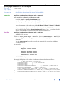
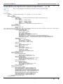
Here is an example of an Multi-scale edge detection wizard task.
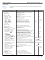
Process Begin
Comments= "Intrepid Audit Stamp v3.7 (release) cut 267-11/ 5/2004"
Name
= WormE
Parameters Begin
Input_Grid Begin
Input_Grid= C:\Intrepid\cookbook\mlevel_edge\sanders_bouguer.ers
Input_Band= 1
Subset Begin
XUpper = -720000.000000
XLower = -900000.000000
YUpper = -1600000.000000
YLower = -1800000.000000
SubsetGrid= C:\datasets\mlevel_edge\subset.ers
Subset End
Input_Grid End
UC_Filtering Begin
Perform_RTP= yes
Levels =
1500,1700,1900,2100,2300,2600,2900,3200,3600,4000,4400,4900,5400,6000,6700,7400,8200,9100,10000,11000,12000,1
3000,14000,16000,18000,20000,22000,24000,27000,30000,
Pre_FFT_Transform Begin
Detrend_Degree= 0
Rolloff_Type= COSINE
Window_Type= None
Fill_Type= SOURCE_GRID
FFT_Grid_Precision= IEEE4ByteComplex
FFT_Border= 120.000000
FFT_Grid_Path= C:\datasets\mlevel_edge\output\FFTGrid.ers
Expanded_Grid_Path= C:\datasets\mlevel_edge\output\ExpandedGrid.ers
Windowed_Grid_Path= C:\datasets\mlevel_edge\output\WindowedGrid.ers
Pre_FFT_Transform End
IGRF Begin
Name
= Specified
Inclination= -45.516918
Declination= 2.876096
FieldStrength= 48889.725439
IGRF End
Rarefy Begin
Height_Mesh_Multiple= 8
Minimum_Rows= 187
Rarefy End
Output_Grids Begin
Folder_Path= output
THD_Prefix= total_hz_deriv
XD_Prefix= x_deriv
YD_Prefix= y_deriv
Grid_Precision= IEEE4ByteReal
Output_Grids End
UC_Filtering End
Vector_Processing Begin
Worm_Processing Begin
Maximum_Point_Separation= 2.0
Worm_Dataset= output/worms..DIR
Worm_Processing End
Line_Processing Begin
Maximum_Straight_Line_Deviation= 8000.0
Minimum_Points_For_Linear= 15
Linear_Dataset= output/linears..DIR
Line_Processing End
Point_Picking Begin
Method = Blakely
Minimum_Anomaly= 0.0
Point_Dataset= output/points..DIR
Point_Depth_Estimation= yes
Point_Picking End
Vector_Processing End
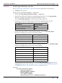
Supplementary_Outputs Begin
Ascii_Point_Dataset= output/asciiPts.wrm
Ascii_Worm_Dataset= output/asciiWorms.str
Ascii_Line_Dataset= output/asciiLines.lin
ArcShape_Point_Dataset= output/arcshapePts.shp
ArcShape_Worm_Dataset= output/arcshapeWorms.shp
MapInfo_Point_Dataset= output/mapInfoPts.mif
MapInfo_Worm_Dataset= output/mapInfoWorms.mif
GoCad_Point_Dataset= output/gocadPts.cad
GoCad_Worm_Dataset= output/gocadWorms.pl
Vrml_Point_Dataset= output/vrmlPts.wrl
Supplementary_Outputs End
Parameters End
Library | Help | Top
© 2012 Intrepid Geophysics
| Back |