1
WPS
When WRF is to be run for a regional domain configuration, the location of the coarse
domain is determined using the ref_lat and ref_lon variables, which specify the
latitude and longitude, respectively, of the center of the coarse domain. If nested domains
are to be processed, their locations with respect to the parent domain are specified with
the i_parent_start and j_parent_start variables; further details of setting up nested
domains are provided in the section on nested domains. Next, the dimensions of the
coarse domain are determined by the variables dx and dy, which specify the nominal grid
distance in the x-direction and y-direction, and e_we and e_sn, which give the number of
velocity points (i.e., u-staggered or v-staggered points) in the x- and y-directions; for the
'lambert', 'mercator', and 'polar' projections, dx and dy are given in meters, and
for the 'lat-lon' projection, dx and dy are given in degrees. For nested domains, only
the variables e_we and e_sn are used to determine the dimensions of the grid, and dx and
dy should not be specified for nests, since their values are determined recursively based
on the values of the parent_grid_ratio and parent_id variables, which specify the
ratio of a nest's parent grid distance to the nest's grid distance and the grid number of the
nest's parent, respectively.
If the regular latitude-longitude projection will be used for a regional domain, care must
be taken to ensure that the map scale factors in the region covered by the domain do not
deviate significantly from unity. This can be accomplished by rotating the projection such
that the area covered by the domain is located near the equator of the projection, since,
for the regular latitude-longitude projection, the map scale factors in the x-direction are
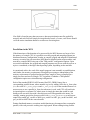
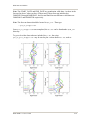
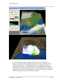
given by the cosine of the computational latitude. For example, in the figure above
showing the unrotated and rotated earth, it can be seen that, in the rotated aspect, New
Zealand is located along the computational equator, and thus, the rotation used there
would be suitable for a domain covering New Zealand. As a general guideline for
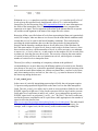
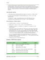
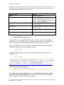
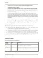
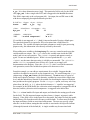
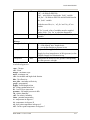
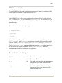
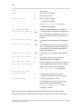
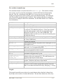
rotating the latitude-longitude projection for regional domains, the namelist parameters
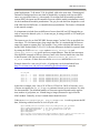
pole_lat, pole_lon, and stand_lon may be chosen according to the formulas in the
following table.
pole_lat
pole_lon
stand_lon
(ref_lat, ref_lon) in N.H.
90.0 - ref_lat
180.0
(ref_lat, ref_lon) in S.H.
90.0 + ref_lat
0.0
-ref_lon
180.0 - ref_lon
For global WRF simulations, the coverage of the coarse domain is, of course, global, so
ref_lat and ref_lon do not apply, and dx and dy should not be specified, since the
nominal grid distance is computed automatically based on the number of grid points.
Also, it should be noted that the latitude-longitude, or cylindrical equidistant, projection
(map_proj = 'lat-lon') is the only projection in WRF that can support a global
domain. Nested domains within a global domain must not cover any area north of
computational latitude +45 or south of computational latitude -45, since polar filters are
applied poleward of these latitudes (although the cutoff latitude can be changed in the
WRF namelist).
Besides setting variables related to the projection, location, and coverage of model
domains, the path to the static geographical data sets must be correctly specified with the
WRF-ARW V3: User’s Guide
3-12